SEVERE Storms LIKELY Friday Night
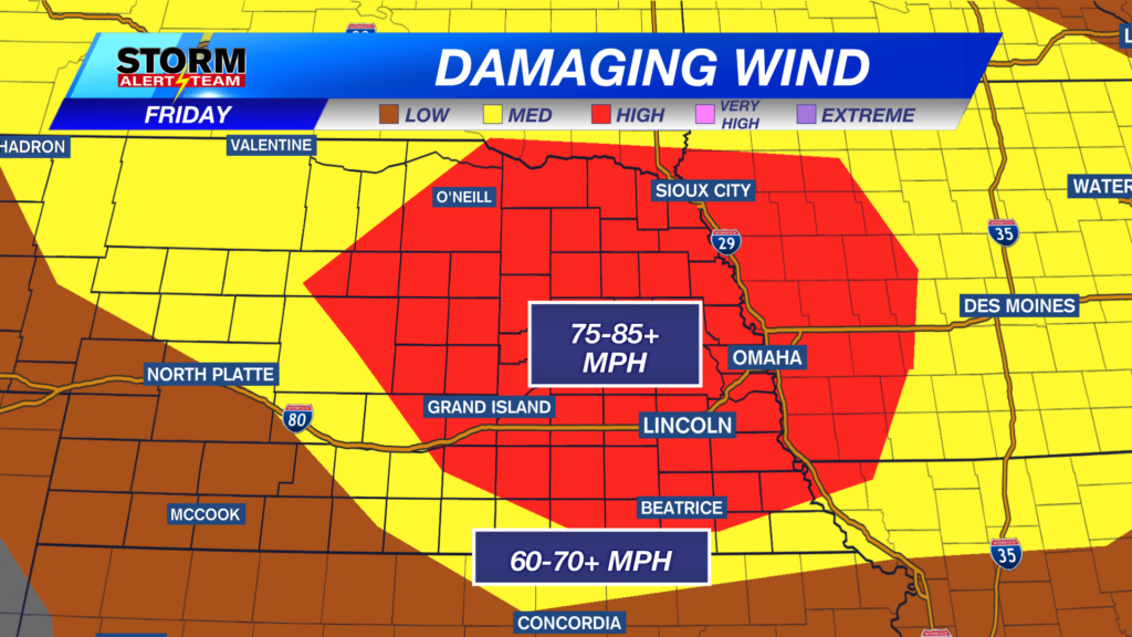
DAMAGING WINDS up to 75-85+mph will be possible from Lincoln/Hastings & areas north of I-80. Localized gusts could exceed 85+ mph near Fremont & Omaha around 7-9pm. Winds will be the main concern with these storms tonight.
- For up-to-the-minute radar: CLICK HERE.
- For the latest warnings: CLICK HERE.
- For a live look at our Nebraska Weather Cams: CLICK HERE.
- And we would love to see video of any storm footage you may get (safely!). You can upload that using our Now Local News App: CLICK HERE.

5-7pm: STRONG storms develop from St. Paul to Onawa, carrying a brief TORNADO threat, LARGE HAIL & DAMAGING winds up to 70+ mph. Lincoln & SE Nebraska could see strong winds near 7pm.

A brief tornado threat will lay from Sioux city down to Holdrege. Some rotation could occur as the storms form into a line this evening.


Hail up to half dollars to golf balls will be possible, especially with the first storms that develop near 5-9pm.

10pm-midnight *LINCOLN*: This will likely be the PEAK time frame for SEVERE storms across SE Nebraska. 70-80+ mph winds, hail & a brief spin up on the tail end near Kearney->Red Cloud.

1-3am *LINCOLN*: Another line of storms will move through from OMA->Hastings. Hail & winds will be the main concerns along with heavy rainfall. STAY TUNED for the latest & stay safe!-

Rain potential lays along a sharp boundary from G.I & areas east. 1-3″+ of rain will be possible within these storms.

SEVERE storms from 5pm-3am Friday. Lincoln will see storms near 10pm into 2am Saturday. Saturday will be quite nice, just HOT. Rain/storm chances farther SW Saturday evening. Next week looks sunny, hot & humid with mid week storm chances.

Meteorologist Houston Hall
Facebook: HHallWX
YouTube: HHallWX


