Mostly Sunny, Warmer on Thursday, Storm Chances Late
Severe Weather Potential:
Latest Update: 11:33 a.m. CDT
Severe weather is possible for central and southwestern Nebraska on Thursday afternoon as we see a shift from the unseasonably warm fall temperatures. The Storm Prediction Center currently has a Marginal Risk (Level 1 out of 5) for severe weather in portions of central and southwestern Nebraska. Small chances for an isolated tornado, quarter-size hail, and 60 mile-per-hour winds this afternoon.
- For up-to-the-minute radar: CLICK HERE.
- For the latest warnings: CLICK HERE.
- For a live look at our Nebraska Weather Cams: CLICK HERE.
- And we would love to see video of any storm footage you may get (safely!). You can upload that using our Now Local News App: CLICK HERE.
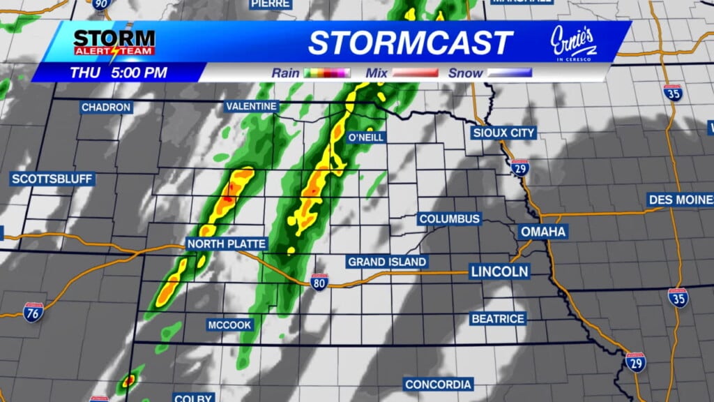
Above is the latest run of Stormcast that shows storms intensifying by 3 p.m. in central Nebraska. Storms slowly march east while dissipating, with showers reaching eastern Nebraska early Friday morning.
Forecast:

It has been a wild ride up until the halfway point in October, here is a few of the highlights from the month so far:
- Warmest Temperature: October 3 – 90 degrees
- Coldest Temperature: October 8 – 39 degrees
- Precipitation (October 1-15): 1.47″
- Average Precipitation (October 1-31): 2.14″

Temperatures starting on the warmer side in Lincoln and will remain well above-average this afternoon.

After coming up just short on Wednesday, we should not have much of an issue reaching the lower 80s today thanks to plenty of sunshine and strong southerly winds.

Upper 70s and lower 80s for much of southeast Nebraska on Thursday, with winds gusting up to 30 miles per hour this afternoon.

We stay above-average for our low temperatures tonight, only reaching the lower 60s despite the chance of a few showers.

Many of us in far southeastern Nebraska will see the lower 60s, with cooler temperatures for central Nebraska in the 50s. All of us are in for a breezy night ahead, with winds gusting up to 25 miles per hour.

Showers will be possible for the first half of Friday as temperatures fall going into the weekend. We stay in the 70s before dropping into the upper 60s on Sunday, where we remain windy heading into the first half of next week. The temperature rollercoaster continues early next week before temperatures settle down into the upper 60s and lower 70s. A few upper-level disturbances could make their way across the plains next week, giving us more opportunities for rain as we head into the back half of the month.
Storm Alert Team Meteorologist
Dominic Ferraro
X: Dom_FerraroWX
Facebook: DomFerraroWX
YouTube: Dom_FerraroWX


