Sunday Evening Storms, Temperatues Drop Monday
Severe Weather Potential:
Latest Update: 5:52 p.m. CDT
We are monitoring the risk of severe weather in southeast Nebraska for Sunday evening. The Storm Prediction Center has issued a Marginal Risk (Level 1 out of 5) for southeast Nebraska this evening, which includes Lincoln. Quarter-size hail, 60 mile per hour wind gusts, and localized flooding will be possible.
- For up-to-the-minute radar: CLICK HERE.
- For the latest warnings: CLICK HERE.
- For a live look at our Nebraska Weather Cams: CLICK HERE.
- And we would love to see video of any storm footage you may get (safely!). You can upload that using our Now Local News App: CLICK HERE.
The latest runs of Stormcast show storms initiating by 8 p.m. CDT this evening. Most models have the line of storms forming to the south and east of Lincoln along the passing cold front. Additional storm development behind the initial line could storms to the Lincoln area. If storms begin to fire earlier in the afternoon, Lincoln will see better chances of seeing severe weather.
Forecast:

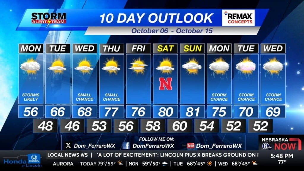
One more day in the 80s for Lincoln on Sunday with a few chances for sprinkles during the afternoon. Storm chances increase as we head toward this evening, with strong winds persisting until then as well.

The incoming cold front will bring cooler temperatures for most of us this evening. Showers and thunderstorms will be possible through Monday morning.

Lows tonight will be in the lower 50s in Lincoln. A cooler evening in the Capital City with storms likely through the overnight hours.

Not a ton of warming across our area tomorrow as a northerly wind will look to balance out any heating we see throughout the day. Heavy cloud cover and showers will also help keep temperatures cooler.

After a very warm weekend, we start the work week in the Capital City with highs in the mid-50s. Strong northerly winds and showers will join us for most of the day.

Temperatures rebound on Tuesday into the mid-60s with sunshine and small rain chances through the middle of this week. Temperatures climb into the 70s and ultimately the lower 80s by next weekend. Storm chances return toward the middle of October.
Storm Alert Team Meteorologist
Dominic Ferraro
X: Dom_FerraroWX
Facebook: DomFerraroWX
YouTube: Dom_FerraroWX


