Last Warm Day Before Snow Thursday
One last day with temperatures in the 50s & 60s. ! Strong NW winds 25-35 mph will occur farther northeast. Sunny in the morning with increasing clouds by the afternoon. Get out and try to enjoy this afternoon before winter makes its frigid return!

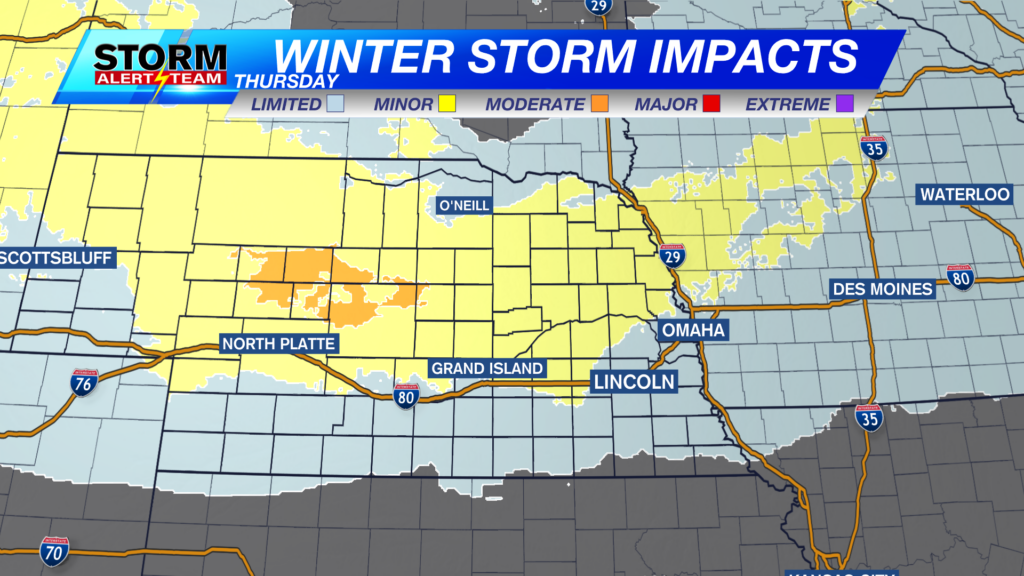
Thursday morning, wet/heavy snow farther NW before moving SSE Thursday afternoon. Some light drizzle will occur across eastern Nebraska near 6-9am. Dry/fluffy blowing snow occurs by noon as the colder air sinks in. The best chance for 2-5″+ looks to be north of G.I. Still uncertainty on positioning as models have been trending a bit southward. South of I-80 has a 30% chance to see 1″ of snow. MELTING will also be a factor due to the very warm temperatures this week.
The farther south you are, the less chance for 1′ of snow. A decent swath of 2-5″ across NW and north central Nebraska. Some localized spots could see near 6″+ near Mullen. Peak timing: 6am-6pm Thursday.

The greatest travel impacts will occur in the middle of the state near Broken Bow & Ord. Blowing snow, reduced visibilities and heavy snow totals will make for impacts Thursday.

Blowing and drifting snow will be a concern through Thursday. Gusts to near 30-35+ mph across the state.

WINTER WEATHER ALERTS are in place starting Thursday morning – Thursday evening. This is due to the heavy snow accumulations up to 3″+ and blowing snow creating reduced visibilities.

Thursday morning, wet/heavy snow farther NW before moving SSE Thursday afternoon. Some light drizzle will occur across eastern Nebraska near 6-9am. Dry/fluffy snow occurs by noon as the colder air sinks in. The best chance for 2-5″+ looks to be north of G.I. Still uncertainty on positioning as models have been trending a bit southward. South of I-80 has a 30% chance to see 1″ of snow. Next week brings warmer air and more chances for precipitation.

Meteorologist Houston Hall
Facebook: HHallWX
YouTube: HHallWX


