Patchy fog Thursday morning; Warming in to the weekend
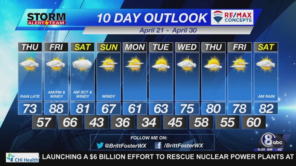
Showers Wednesday morning over far eastern Nebraska has left low level moisture in the atmosphere. As winds lighten overnight in to Thursday morning, areas of patchy fog will develop. The best chance for fog will be along and east of Highway 77 from Lincoln to Beatrice and east to the Nebraska/Iowa border.
Once the fog burns off, skies should become mostly sunny by late Thursday morning. You will start to notice mid/high-level clouds streaming in from the south Thursday afternoon. Temperatures will top out in the lower to middle 70°s. Winds could gust to 30 mph out of the east by late afternoon.
A warm front will lift north in to Nebraska Thursday evening. The warm front will provide enough lift to produce scattered showers and a few thunderstorms. The chance for precipitation will continue past midnight Friday morning.
A few of the thunderstorms that develop along the warm front will have the potential to produce large hail, especially near the Kansas/Nebraska state line. It will be possible for a few of the thunderstorms to become severe. It is something we will keep an eye on.
SUMMER TEMPERATURES RETURN
It looks like many will make a run at 90° Friday afternoon. Mostly sunny skies, strong southerly winds, and a stronger late April sun will send temperatures quickly in to the 80°s and 90°s. As the atmosphere cooks during the afternoon, a few strong to severe thunderstorms will be possible Friday evening. At this time, it appears the best chance for stronger thunderstorms will be in central Nebraska.
– Chief Meteorologist John Dissauer


