Warm Friday- Bitter Cold Weekend
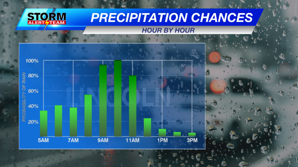
Today will be our last warm day before the weekend cold! West winds will gust to around 30+ mph across the state with temperatures in the 60s and 70s. Tonight, cloudy skies will gradually take over. Tonight into early Saturday morning, a few rain showers are likely in NE and eastern Nebraska. Best chance for accumulating rain will be north of I-80 through Saturday night.

Saturday morning brings the best chance for rain across eastern Nebraska with temperatures in the upper 30s and low 40s. By Saturday night, COLDER air filters in, possibly mixing in a few snowflakes across northeast Nebraska. NO accumulation is expected thanks to STRONG winds gusting 45+ mph and warmer ground temperatures. Expect temperatures to fall into the 20s with WIND CHILL values in the single digits through Monday morning.
The best chance of rain will be north of the Omaha metro through Saturday night. Most of us will likely see a few hundredths.

Today, high temperatures will warmup into the upper 60s and some lower 70s statewide under sunny skies. Cloud cover will become more widespread across western Nebraska by the afternoon and evening.

Tonight, expect temperatures a bit colder as the front edges into the state. Temperatures in the low to mid 30s under mostly cloudy skies and light west winds. A few light rain showers will be possible across NE and eastern Nebraska.

A chilly and COLD weekend ahead! High temperatures in the 50s Saturday with a few peeks of sun and light rain. Sunday morning turns DRY, BRISK, and COLD, but sunshine returns through the day — helping it feel a bit better outside.

Sunday morning, temperatures will feel like the single digits and teens across much of the state.

Monday morning, make sure to have an extra layer or two! Temperatures will feel well below freezing.

Enjoy Friday afternoon and the warm temperatures. A cold and windy weekend is ahead with lows near the lower teens Sunday and Monday morning. Sunshine and milder temps make a comeback next week like nothing ever happened! Veterans Day is shaping up to be BEAUTIFUL! Warming up 20-25 degrees from Monday. Our next rain chance looks to come near November 17-20.

Meteorologist Houston Hall
Facebook: HHallWX