Tuesday Evening Severe Storm Potential – June 9, 2026
Severe Weather Potential:

A Tornado Watch has been issued for portions of central and western Nebraska as storms begin to move into the western edge of the state. Several counties along the Kansas-Nebraska border are also under a Severe Thunderstorm Watch. Both watches go until 12 a.m. CDT on Wednesday, June 10. Additionally, at 8:35 p.m. CDT, a Tornado Watch has been issued for northeast Nebraska until 3 a.m. CDT on Wednesday, June 10.
- For up-to-the-minute radar: CLICK HERE.
- For the latest warnings: CLICK HERE.
- For a live look at our Nebraska Weather Cams: CLICK HERE.
- And we would love to see video of any storm footage you may get (safely!). You can upload that using our Now Local News App: CLICK HERE.

Scattered to numerous severe storms will be possible across the state on Tuesday night. An Enhanced Risk (Level 3 out of 5) is in place for central portions of the state, where the greatest potential for severe weather will be over the next several hours.
A couple of tornadoes, golf ball-sized hail and 60 mph wind gusts are possible in the strongest storms across the central portions of the state tonight. Storms are expected to weaken heading into eastern Nebraska, where we could see large hail and damaging winds.
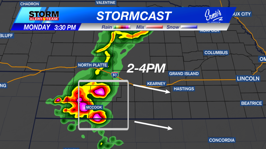
Above is the latest run of StormCast with a look at storm timing across the state this evening. Storms will also be possible very late Wednesday evening into early Thursday morning.

Scattered severe storms could be possible for southeast Nebraska very late Wednesday into early Thursday morning. A Sight Risk (Level 2 out of 5) is in place as the strongest storms could carry large hail and damaging winds.

Next up, Wednesday evening’s storms may carry over into early Thursday morning. Lincoln remains under a Slight Risk as storms depart the area before lunch.
Forecast:

Looking ahead to Wednesday, it will be a very mild start to the day in eastern Nebraska with lows in the 70s.

We will try again for highs in the low 90s before chances for storms increase very late in the day on Wednesday.

Temperatures will be generally cooler than the past several days as we close out the work week. Highs return to the lower and middle 80s, coupled with storm chances by the weekend. The mid-70s for the start of next week will certainly be refreshing.
Storm Alert Team Meteorologist
Dominic Ferraro
X: DomFerraroWX
Facebook: DomFerraroWX
YouTube: DomFerraroWX