Isolated Friday Storms, Storm Chances Increase for Father’s Day Weekend
Severe Weather Potential:

Chances will increase for an isolated strong to severe storm for southwest and south-central Nebraska on Friday afternoon. A Marginal Risk (Level 1 out of 5) of severe weather is in place. It will likely be light scattered showers for most of us, though a storm or two could be capable of quarter-sized hail and wind gusts up to 60 miles per hour.
Here is a look at the timing for showers and thunderstorms tonight, according to the latest run of StormCast.

Saturday brings better chances of severe weather across the state, with the highest potential along the Kansas-Nebraska border. An Enhanced Risk (Level 3 out of 5) is in place for south-central Nebraska. A Slight Risk (Level 2 out of 5) in place from the panhandle to southeast Nebraska. Scattered to numerous severe storms will be possible late Saturday night into early Sunday morning.
A couple of tornadoes cannot be ruled out Saturday afternoon and evening, with the risk of large hail and damaging winds increasing by early Sunday morning as storms move south and east.

Additionally, the risk for flash flooding is elevated for south-central and southeast Nebraska. Localized rainfall totals between three and five inches will be possible in southeast Nebraska.

As for storm timing, storms will become more widespread by midnight and move south and east across the state during the early morning hours on Sunday.

Models are getting closer to agreeing on the timing of storms in southeast Nebraska. Our best chance looks to be after midnight, which means having ways to be alerted to severe weather overnight will be important!
Forecast:

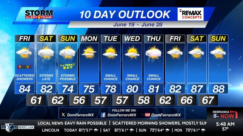
Despite a few passing clouds and chances for showers, highs will climb to the lower and middle 80s along the Interstate-80 corridor.

We are looking at a seasonal June afternoon in Lincoln with a few clouds, although a brief shower or two may move through this evening.

Temperatures tonight will range from the lower to the middle 60s.

After a few brief showers earlier in the evening, mostly cloudy skies will continue overnight for the Capital City.

Temperatures will cool through Father’s Day weekend, with highs dropping to the 70s to start next week. An active weather pattern sticks around through next week, hence another round of storms for the middle of the week. Temperatures remain below average until the last few days in June.
Storm Alert Team Meteorologist
Dominic Ferraro
X: DomFerraroWX
Facebook: DomFerraroWX
YouTube: DomFerraroWX


