Warm Friday Before Summer Heat

Saturday Evening SEVERE WX:
Saturday morning will bring widespread FOG across the state. Depending on when the fog lifts, this will determine if we see a few severe storms by the evening & night time hours. We will have ample moisture, energy & the LLJ will be right across eastern Nebraska giving us the components for severe weather.

Here is a look at severe weather potential Saturday: The HRRR model has isolated severe storms forming out west with a northeast track. The EURO model has a storm or two moving SSE, carrying a DAMAGING wind threat through Saturday night. We will monitor the latest trends.

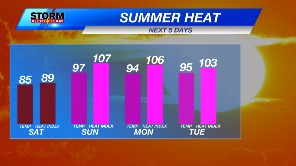
Starting Sunday, summer will make a strong return! Temperatures will stay in the 90s with feel like temperatures in the triple digits through next week.

The humidity will also skyrocket! Dew points reaching the low to upper 70s, which is a lot of moisture for this far north.

Winds will also turn gusty starting Saturday through next week. SE winds will bring us all of this heat and humidity!

A HOT & HUMID weekend ahead with spotty rain/storm chances Saturday night, Tuesday & Wednesday of next week.

Meteorologist Houston Hall
Facebook: HHallWX
YouTube: HHallWX