EXTREME Heat Through Tuesday
High temperatures Sunday will range from 88-99 degrees! The hottest temperatures will occur farther east where the bulk of the moisture will lay. SE Nebraska will likely see the breeziest conditions with south winds up to 20 mph.

HOLY HUMIDITY! Dew points across eastern Nebraska will exceed the mid to upper 70s Sunday afternoon. That is very muggy for this far north!

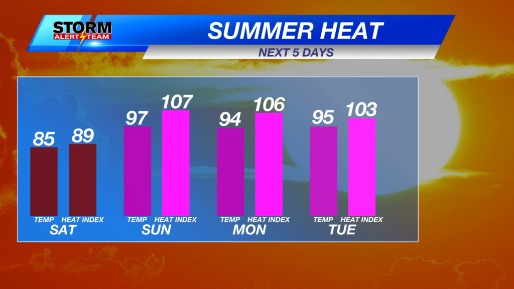
HEAT INDEX values near 100-110 degrees for much of the east Sunday afternoon.

Starting Sunday, summer will make a strong return! Temperatures will stay in the 90s with feel like temperatures in the triple digits through Wednesday.

HEAT ADVISORIES & EXTREME HEAT WARNINGS are in effect Sunday-Tuesday night. Feel like temperatures between 105-110 degrees will be likely each afternoon. Take extra precautions if working outside this week.

Monday night SEVERE WX:
Monday night could bring some storms that would carry a DAMAGING WIND & HAIL threat north of I-80. Details will get smoother as this system continues to move east through Sunday. Stay tuned for updates. *When it’s HOT & you think storms can’t form, just know storms can form & usually carry a wind threat due to the quick collapse after sunset.*

Storms look to develop from Lexington up towards Sioux City Monday evening. A few tail end storms could occur Monday evening.

A HOT, HUMID & sunny Sunday. Monday will be another hot, windy & sunny day with evening/night rain & storm chances north of I-80. This pattern will continue through Wednesday. A slow cool down after July 4th!

Meteorologist Houston Hall
Facebook: HHallWX
YouTube: HHallWX