Summer Heat Surges to Start the Week

Sunday was just the start of what will be a very hot and humid close to the month of June. Chances of showers and thunderstorms are there, but will be fairly isolated, giving us little relief from the summertime heat.
The majority of the day will be cloud-free in eastern Nebraska, though keep an eye on the radar after sunset. The latest runs of StormCast show chances for isolated showers and storms through the overnight.

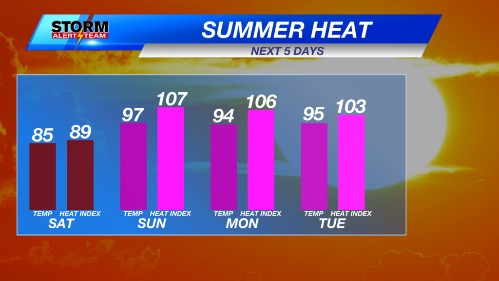
A Heat Advisory remains in place for southeast Nebraska until 9 p.m. CDT on Tuesday, June 30. An Extreme Heat Warning remains in place for Douglas and Sarpy Counties, along with the majority of Iowa. Heat indices across the region will range from 105° to 110° in the coming days.

Low temperatures in eastern Nebraska may struggle to drop to the 70s. Cooler, though still mild out west, with lows in the 50s.

Cloud cover will be minimal for Lincoln this evening as warm temperatures and strong winds continue through the overnight.

High temperatures will remain well above average in eastern Nebraska to start the work week. Air temperatures are expected in the mid to upper 90s on Monday afternoon.

Strong southerly winds will continue to usher in higher levels of humidity, bumping heat indices above 100° for areas east of the Tri-Cities.

By 8 a.m in Lincoln, it is already hot. There is no way to sugarcoat it. Hot, humid and breezy sums up our Monday afternoon in the Capital City.

Isolated to scattered storms will be possible late Monday into early Tuesday morning. A Slight Risk (Level 2 out of 5) of severe weather is in place for northeast Nebraska, with a Marginal Risk (Level 1 out of 5) extending to south-central Nebraska. All severe hazards will be possible in the area shaded in yellow. Quarter-sized hail and wind gusts up to 60 miles per hour would be possible for a strong storm along and south of Interstate 80.

A low-end risk of severe weather cannot be ruled out for late Tuesday night into Wednesday morning. Isolated severe storms will be possible across the state, though not everyone will see storms.

We will go well into July before seeing any relief from the above-average temperatures. Any chances of precipitation look fairly isolated for the moment, as an upper-level ridge aims to keep the eastern half of the United States battling the heat.
Storm Alert Team Meteorologist
Dominic Ferraro
X: DomFerraroWX
Facebook: DomFerraroWX
YouTube: DomFerraroWX