FLASH FLOODING Threat Through Tonight
This morning through 11am-noon, most of us will stay dry. After 1pm: Rain spreads across much of Nebraska, becoming heavier at times. The heaviest rain is expected from 5pm-midnight across SE Nebraska.

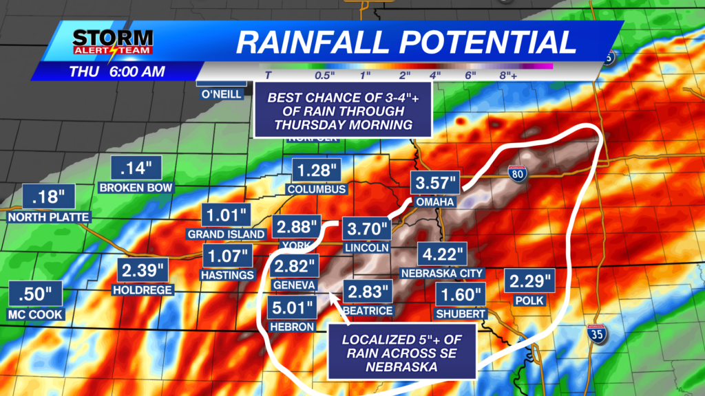
24-HR rainfall totals through Thursday morning: Areas farther west will likely see 1.5–3.0″+ of rain. The best chance for 3.5–6.0″+ will be from Omaha down through Lincoln to Hebron.

11am- 3pm: As we get later into the afternoon, rainfall will become more moderate across SE Nebraska.

4-7pm: Widespread heavy rain & T-storms persist from G.I to Lincoln & south. A few severe storms with gusty winds & brief rotations could be possible south of i-80.

8pm-midnight: Moderate to heavy rain continues with rain accumulations across SE Nebraska likely already exceeding 3″ by this time.

A few brief & weak spin ups could occur this evening across SE Nebraska. TIMING: 6-11pm

A few rouge wind gusts up to 60 mph will be possible within this storm complex. Mainly south of i-80.

Temperatures look to stay near 66° – 76° through the next 10 days! *Morning temperatures look to stay near 44° – 55°! Some areas could see their coldest temperatures Friday & Saturday morning. The best rain chances are all day today-Thursday morning. This weekend and next week is shaping up AMAZING! Sunny skies & cool temperatures with less active rain chances.

Meteorologist Houston Hall
Facebook: HHallWX
YouTube: HHallWX