Cooler Again with Showers on Sunday, Hot and Storms for Monday
Weather Headlines:

A few chances of showers, especially early in the day, look to keep temperatures cooler on Sunday. Overcast skies remain through the afternoon, with highs reaching the lower 70s.
A spot shower or two cannot be ruled out the rest of the way on Saturday, though better chances lie ahead for Sunday. Showers and a few rumbles of thunder are possible through midday, according to the latest run of StormCast.

Chances for severe weather are increasing on Monday, though it will depend on the morning round of showers and storms clearing out in time. A Slight Risk (Level 2 out of 5) of severe weather is in place for Monday evening. If storms can live up to their full potential, an isolated tornado or two, large hail and damaging winds will all be possible in the strongest storms.

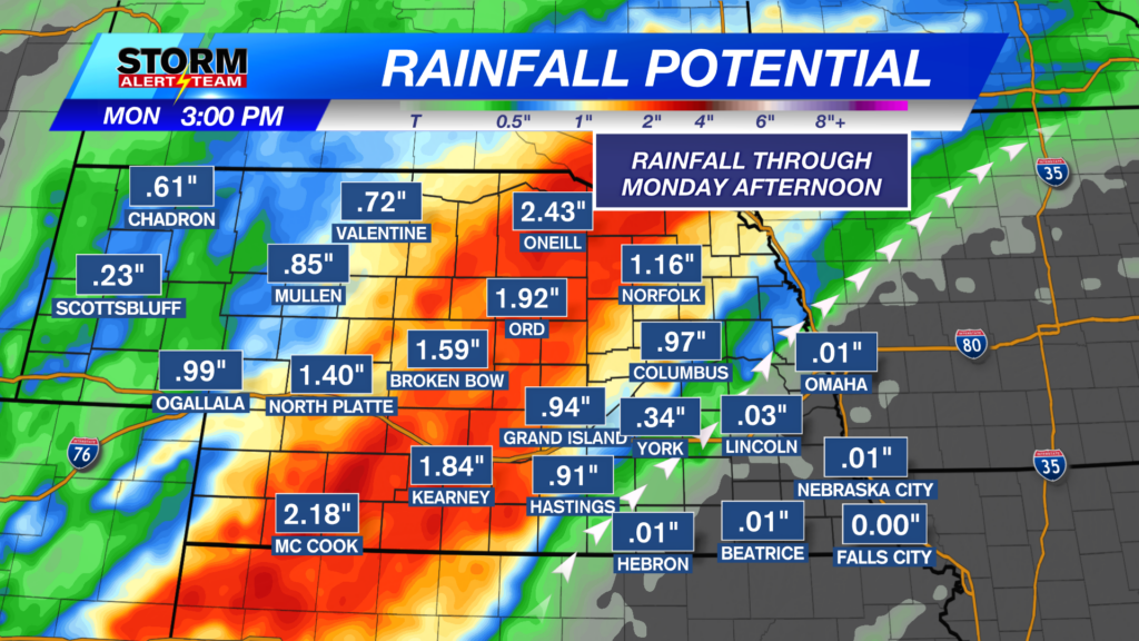
With multiple upper-level disturbances expected to move through during the week ahead, some of us may see significant rainfall over the next week. The best chances for higher rainfall totals look to be in eastern Nebraska.
Forecast:

Lows tonight should be near average for most of the state as temperatures fall to the middle 50s. Southeast Nebraska remains a touch warmer under overcast skies.

A stray shower is unlikely, but possible in the Lincoln area through the overnight hours. Otherwise, expect mostly cloudy skies through Sunday morning.

Temperatures for most of the state are expected to struggle on Sunday afternoon. Highs will reach the upper 60s to lower 70s for most, with warmer weather for the panhandle.

With mostly cloudy skies and chances for showers, we will not see much warming for the Capital City. Temperatures are expected to reach the lower 70s later in the afternoon.

Much warmer for those temperatures on Monday, with a surge of southerly winds bringing heat and humidity. This change in the pattern will prime storm chances across the area on Monday evening.

The upper air pattern remains busy for the work week with daily chances for showers and storms. Chances for severe weather will be monitored, though seasonally cool temperatures should help keep storms mild. Fall weather looks to stick around through the start of astronomical fall in late September.
Storm Alert Team Meteorologist
Dominic Ferraro
X: DomFerraroWX
Facebook: DomFerraroWX
YouTube: DomFerraroWX