Monday Morning Showers, Evening Storm Chance
Weather Headlines:

Showers will usher in the workweek, followed by a chance of isolated storms Monday evening. A Marginal Risk (Level 1 out of 5) of severe weather is in place from south-central to northeast Nebraska.
- For up-to-the-minute radar: CLICK HERE.
- For the latest warnings: CLICK HERE.
- For a live look at our Nebraska Weather Cams: CLICK HERE.
- And we would love to see video of any storm footage you may get (safely!). You can upload that using our Now Local News App: CLICK HERE.
Damaging winds would be the main concern in the strongest storms that we could see Monday evening, though a brief spin-up tornado or two cannot be ruled out. Afternoon cloud cover could have an impact on storm intensity as well.
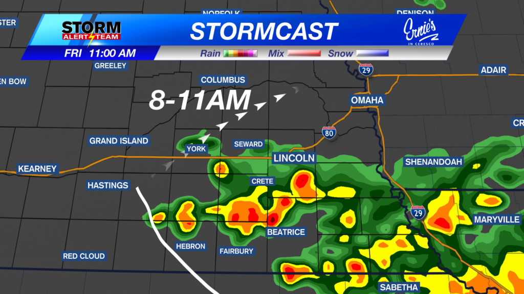
The latest runs of StormCast show showers across the state through Monday morning. We will see a brief break in the action, followed by additional storm chances Monday evening. Precipitation remains possible on the backside of this system, moving through the area on Tuesday morning.

As an area of low pressure continues to move into the central plains, winds are expected to increase across the state. Winds could gust between 45 to 50 miles per hour throughout the day on Monday.
Forecast:

Cloud cover should help keep overnight lows in the 50s statewide. Chances for precipitation increase through the early morning hours.

Overcast and strong winds will highlight our forecast overnight in Lincoln. Chances for showers and thunderstorms could join us for the Monday morning commute.

Warmer temperatures are expected for the eastern half of the state ahead of an incoming cold front. Highs will range from the middle to upper 70s in the east, with highs as cool as the 50s to the west.

We should see rain chances taper off late Monday morning in the Capital City before additional storm chances arrive close to dinnertime.

Most of the state will see high temperatures in the 40s and 50s behind the front, with additional showers possible as the upper-level disturbance moves to our east.

Fall-like temperatures grace the forecast through the work week, with highs in the 50s and 60s. Precipitation chances look to quiet down until at least next weekend, but best to keep an ey on the latest forecast!
Storm Alert Team Meteorologist
Dominic Ferraro
X: DomFerraroWX
Facebook: DomFerraroWX
YouTube: DomFerraroWX